קובץ:Air massif sat map south.png
קפיצה לניווט
קפיצה לחיפוש
אין גרסה ברזולוציה גבוהה יותר.
Air_massif_sat_map_south.png (338 × 426 פיקסלים, גודל הקובץ: 235 ק"ב, סוג MIME: image/png)
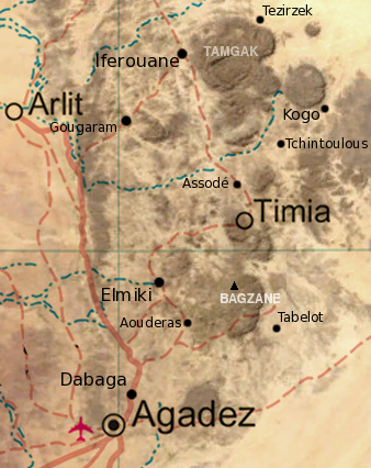
| תיאור | Map of the southern half of the Air Massif, northern Niger. Created from an overlay of PD File:Un-niger.png and PD File:Niger_BMNG.png, plus map locations derived from fallingrain.com. |
| תאריך יצירה | (UTC) |
| מקור | |
| יוצר |
|
| זוהי תמונה מרוטשת, זאת אומרת שהתמונה שונתה בצורה דיגיטלית מהמקור. Modifications: Overlay of two images, scale, add locations, names. את התמונה המקורית ניתן לראות ב: Niger BMNG.png.
|
| ברצוני, בעלי זכויות היוצרים על יצירה זו, לשחרר יצירה זו לנחלת הכלל. זה תקף בכל העולם. יש מדינות שבהן הדבר אינו אפשרי על פי חוק, אם כך: אני מעניק לכל אחד את הזכות להשתמש בעבודה זו לכל מטרה שהיא, ללא תנאים כלשהם, אלא אם כן תנאים כאלה נדרשים על פי חוק. |
יומן העלאה מקורי
This image is a derivative work of the following images:
- Image:Niger_BMNG.png licensed with PD-WorldWind
- 2006-04-26T18:55:04Z Hautala 2427x1919 (3901170 Bytes) {{PD-WorldWind}} Satellite image of Niger in September 2004. Screenshot from NASA World Wind, Blue Marble Next-Generation layer. [[Category:Satellite images of countries]]
Uploaded with derivativeFX
היסטוריית הקובץ
ניתן ללחוץ על תאריך/שעה כדי לראות את הקובץ כפי שנראה באותו זמן.
| תאריך/שעה | תמונה ממוזערת | ממדים | משתמש | הערה | |
|---|---|---|---|---|---|
| נוכחית | 20:31, 17 בדצמבר 2008 | | 426 × 338 (235 ק"ב) | wikimediacommons>T L Miles | {{Information |Description= Map of the southern half of the Air Massif, northern Niger. Created from an overlay of PD File:Un-niger.png and PD File:Niger_BMNG.png, plus map locations derived from fallingrain.com. |Source=*Image:Niger_BMNG.png |Date= |
שימוש בקובץ
הדף הבא משתמש בקובץ הזה: