קובץ:RogersCrkNorthHayward.gif
קפיצה לניווט
קפיצה לחיפוש
אין גרסה ברזולוציה גבוהה יותר.
RogersCrkNorthHayward.gif (640 × 440 פיקסלים, גודל הקובץ: 23 ק"ב, סוג MIME: image/gif)
| תיאור |
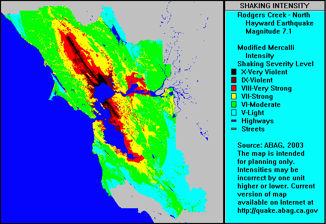
English: ABAG shake map for Rodgers Creek Fault Zone and north Hayward Fault Zone (single event) with colors representing ground motion in the Mercalli Intensity Scale. Note that colors used in the Mercalli article do not correspond to colors used in the ABAG map shown here — use Roman numerals for cross reference. |
| תאריך יצירה | 5 בספטמבר 2004 (תאריך העלאה מקורי) |
| מקור | הועבר מ- en.wikipedia לוויקישיתוף. |
| יוצר |
מעלה היצירה המקורי היה Leonard G. מוויקיפדיה האנגלית |
רישיון
קובץ זה נמצא בנחלת הכלל, כי it is a work by or prepared for a tax-supported government agency, the Association of Bay Area Governments (ABAG).
From the ABAG web page [1]:
במידה ושחרור זכויות היוצרים לנחלת הכלל אינו אפשרי חוקית: אנא ודא כי הסיבה שניתנה לעיל עולה בקנה אחד עם מדיניות הרישוי של ויקישיתוף.
|
יומן העלאה מקורי
תיאור הקובץ המקורי נמצא כאן. כל שמות המשתמשים הבאים מתייחסים ל-en.wikipedia.
- 2004-09-05 03:57 Leonard G. 640×440× (23379 bytes) ABAG shake map for Rodgers Creek and North Hayward - public domain image
היסטוריית הקובץ
ניתן ללחוץ על תאריך/שעה כדי לראות את הקובץ כפי שנראה באותו זמן.
| תאריך/שעה | תמונה ממוזערת | ממדים | משתמש | הערה | |
|---|---|---|---|---|---|
| נוכחית | 08:47, 1 במאי 2009 | | 440 × 640 (23 ק"ב) | wikimediacommons>Carlog3 | {{Information |Description={{en|en:ABAG shake map for en:Rodgers Creek Fault Zone and north en:Hayward Fault Zone (single event) with colors representing ground motion in the en:Mercalli Intensity Scale. Note that colors used in th |
שימוש בקובץ
הדף הבא משתמש בקובץ הזה: